APRIL 2007 NEWSLETTER
We had our April meeting at the Fayston Town Hall on Tuesday, April 3, 2007.
Nine members attended.
TRAILS
The trails are officially closed for the season. 175 TMA’s were purchased for the 2006-2007 season.
SLATE OF OFFICERS
The following nominations were made and will be voted on at the May meeting:
President: Art Dages
Vice President: Howard L. Emerson III
Secretary: Cathi Dages
Treasurer: Lois De Heer
Trailmaster: Marty De Heer
Ass’t Trailmaster: Paul Pizzale
Safety Officer: Skip Wallace
Write–in nominations are welcome.
Next meeting: May 1, 2007, 7:00 PM at the Fayston Town Hall. Hope to see you there!!
Thursday, April 26, 2007


Friday, March 30, 2007
Club Meeting--Tuesday April 3
Our next club meeting will be held at the Fayston Town Hall on Tuesday April 3 at 7PM.
We have many things to discuss including the nomination of club officers as well as new trail projects and late summer trail work.
Hope to see you there.
We have many things to discuss including the nomination of club officers as well as new trail projects and late summer trail work.
Hope to see you there.
Sunday, March 25, 2007
Saturday's Hot Dog Roast and Ride
Members of the Ridge Runners met at 10AM at the Gravel Pit and rode up through Camels Hump State Park and then up to the top of the Huntington Ridge. We found good snow up in the park and at the top of the ridge and little to no snow in between. The snow was melting fast and sadly the season has come to an end unless we receive another storm.


Smokey Bear is prowd of Reggie for safely extinguishing the fire.
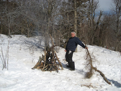


Smokey Bear is prowd of Reggie for safely extinguishing the fire.

Wednesday, March 21, 2007
March Newsletter
MARCH 2007 NEWSLETTER
Our March meeting was held at the Fayston Town Hall on Tuesday, March 13th, 2006. Ten members attended.
Special thanks from all the club members who were out enjoying the trails while our groomers were out working. Thank you Doug Wilson, Paul Pizzale, Skip Wallace, Peanut Ferris, Michael Quinneville, Stewart Holstrom and Lenny Scofield for a great job this season
Our annual progressive dinner was a great success with twenty-one members enjoying good food and great company. We also enjoyed perfect weather and perfect trail conditions. Thanks to our hosts: Reggie & Kathi Orr, Paul Pizzale, Bettina Olivera, and Franz Kluckner.
The MRRR blog site is: http://madriverridgerunners.blogspot.com. Please contact Tony vastridgerunner@gmail.com if you have anything to be posted. Tony continues to update the site regularly and provide current information about club happenings.
It is that time of year when we vote for a new slate of officers. If you are interested in any position, please Contact Art Dages or come to the April meeting. The nominations will be accepted at the April meeting and the slate of officers will be voted on at the May meeting.
Next meeting: April 3,2007 - 7:00 PM at the Fayston Town Hall. Hope to see you there!!
Our March meeting was held at the Fayston Town Hall on Tuesday, March 13th, 2006. Ten members attended.
Special thanks from all the club members who were out enjoying the trails while our groomers were out working. Thank you Doug Wilson, Paul Pizzale, Skip Wallace, Peanut Ferris, Michael Quinneville, Stewart Holstrom and Lenny Scofield for a great job this season
Our annual progressive dinner was a great success with twenty-one members enjoying good food and great company. We also enjoyed perfect weather and perfect trail conditions. Thanks to our hosts: Reggie & Kathi Orr, Paul Pizzale, Bettina Olivera, and Franz Kluckner.
The MRRR blog site is: http://madriverridgerunners.blogspot.com. Please contact Tony vastridgerunner@gmail.com if you have anything to be posted. Tony continues to update the site regularly and provide current information about club happenings.
It is that time of year when we vote for a new slate of officers. If you are interested in any position, please Contact Art Dages or come to the April meeting. The nominations will be accepted at the April meeting and the slate of officers will be voted on at the May meeting.
Next meeting: April 3,2007 - 7:00 PM at the Fayston Town Hall. Hope to see you there!!
Sunday, March 18, 2007
Late Winter Snowstorm!!!
Over the last few days we received 20-30" of light dry powder and conditions have improved dramtically. Our groomers were out in full force and the majority of our trail system has now been groomed. Conditions are great for this time of the year and everyone should get out and ride while they can.
The following pics were taken on Sunday 3/18.


The following pics were taken on Sunday 3/18.


Friday, March 16, 2007
Winter Storm Warning
Time to gas up the sleds.......
...WINTER STORM WARNING IN EFFECT FROM 6 PM THIS EVENING TO 8 PM EDT SATURDAY...
THE NATIONAL WEATHER SERVICE IN BURLINGTON HAS ISSUED A WINTER STORM WARNING...WHICH IS IN EFFECT FROM 6 PM THIS EVENING TO 8 PM SATURDAY FOR THE ENTIRE CHAMPLAIN VALLEY AND THE NORTH CENTRAL AND NORTHEAST SECTIONS OF VERMONT. THE WINTER STORM WATCH IS NO LONGER IN EFFECT.
SNOW WILL OVERSPREAD THE AREA TONIGHT AND BE HEAVY AT TIMES THROUGH THE MORNING HOURS ON SATURDAY. THE SNOW WILL PERSIST SATURDAY AFTERNOON BEFORE TAPERING OFF A BIT SATURDAY NIGHT. TOTAL SNOW ACCUMULATIONS ACROSS THE ENTIRE CHAMPLAIN VALLEY...AND THE NORTH CENTRAL AND NORTHEAST SECTIONS OF VERMONT WILL BE IN THE 12 TO 20 INCH RANGE. GUSTY NORTH TO NORTHEAST WINDS LATE TONIGHT AND SATURDAY WILL RESULT IN SOME BLOWING SNOW AND ENHANCE THE POTENTIAL FOR HAZARDOUS TRAVEL CONDITIONS.
...WINTER STORM WARNING IN EFFECT FROM 6 PM THIS EVENING TO 8 PM EDT SATURDAY...
THE NATIONAL WEATHER SERVICE IN BURLINGTON HAS ISSUED A WINTER STORM WARNING...WHICH IS IN EFFECT FROM 6 PM THIS EVENING TO 8 PM SATURDAY FOR THE ENTIRE CHAMPLAIN VALLEY AND THE NORTH CENTRAL AND NORTHEAST SECTIONS OF VERMONT. THE WINTER STORM WATCH IS NO LONGER IN EFFECT.
SNOW WILL OVERSPREAD THE AREA TONIGHT AND BE HEAVY AT TIMES THROUGH THE MORNING HOURS ON SATURDAY. THE SNOW WILL PERSIST SATURDAY AFTERNOON BEFORE TAPERING OFF A BIT SATURDAY NIGHT. TOTAL SNOW ACCUMULATIONS ACROSS THE ENTIRE CHAMPLAIN VALLEY...AND THE NORTH CENTRAL AND NORTHEAST SECTIONS OF VERMONT WILL BE IN THE 12 TO 20 INCH RANGE. GUSTY NORTH TO NORTHEAST WINDS LATE TONIGHT AND SATURDAY WILL RESULT IN SOME BLOWING SNOW AND ENHANCE THE POTENTIAL FOR HAZARDOUS TRAVEL CONDITIONS.
Thursday, March 15, 2007
Winter Storm Watch
The heavy rain, temps in the 50's and fog this past week has taken its toll on our trail system. The Mad River was at flood stage earlier today and the fields along the river were flooded. It was starting to look like the season was over and then the National Weather Service released this forecast.
...WINTER STORM WATCH IN EFFECT FROM FRIDAY EVENING THROUGH SATURDAY AFTERNOON...
THE NATIONAL WEATHER SERVICE IN BURLINGTON HAS ISSUED A WINTER STORM WATCH FOR NORTH CENTRAL AND NORTHEAST VERMONT...WHICH IS IN EFFECT FROM FRIDAY EVENING THROUGH SATURDAY AFTERNOON.
A TOTAL SNOW AND SLEET ACCUMULATION OF 10 TO 20 INCHES IS EXPECTED BY EARLY SATURDAY EVENING...WITH THE HEAVIEST ACCUMULATIONS EXPECTED OVER THE HIGHER ELEVATIONS.
SNOW IS EXPECTED TO DEVELOP FRIDAY NIGHT AND BECOME HEAVY AFTER MIDNIGHT. THE HEAVY SNOW WILL CONTINUE INTO EARLY SATURDAY AFTERNOON AND MAY BE BRIEFLY MIXED WITH SLEET AT TIMES.
PLEASE STAY TUNED TO NOAA WEATHER RADIO...YOUR LOCAL MEDIA...OR GO TO WWW.WEATHER.GOV/BURLINGTON FOR FURTHER UPDATES ON THIS DEVELOPING WINTER STORM.
...WINTER STORM WATCH IN EFFECT FROM FRIDAY EVENING THROUGH SATURDAY AFTERNOON...
THE NATIONAL WEATHER SERVICE IN BURLINGTON HAS ISSUED A WINTER STORM WATCH FOR NORTH CENTRAL AND NORTHEAST VERMONT...WHICH IS IN EFFECT FROM FRIDAY EVENING THROUGH SATURDAY AFTERNOON.
A TOTAL SNOW AND SLEET ACCUMULATION OF 10 TO 20 INCHES IS EXPECTED BY EARLY SATURDAY EVENING...WITH THE HEAVIEST ACCUMULATIONS EXPECTED OVER THE HIGHER ELEVATIONS.
SNOW IS EXPECTED TO DEVELOP FRIDAY NIGHT AND BECOME HEAVY AFTER MIDNIGHT. THE HEAVY SNOW WILL CONTINUE INTO EARLY SATURDAY AFTERNOON AND MAY BE BRIEFLY MIXED WITH SLEET AT TIMES.
PLEASE STAY TUNED TO NOAA WEATHER RADIO...YOUR LOCAL MEDIA...OR GO TO WWW.WEATHER.GOV/BURLINGTON FOR FURTHER UPDATES ON THIS DEVELOPING WINTER STORM.
Tuesday, March 13, 2007
Sunday, March 04, 2007
Morrisville Overnight Ride
Members of the Ridge Runners went on an overnight ride to Morrisville this weekend. We left from Kenyon's on Saturday morning and were treated to 10" of fresh powder on top of a nicely groomed base. The group rode over to Northfield and then through Williamstown, Barre, and Plainfield eventually stopping for lunch and gas in Hardwick. After a quick meal, we rode over Lake Elmore ending up in Morrisville with 110 miles on the trip odometer for the day. We enjoyed drinks and dinner at the Charlmont Restaurant and an overnight stay at the Sunset Motor Inn.
On Sunday morning we awoke to another 6" of fresh snow and headed west on the Lamoille Valley Rail Trail rail trail Johnson stopping in Jeffersonville for gas. We continued west until reaching Essex where we then turned south through Underhill, Richmond, Bolton, and Waterbury before eventually riding over the Winooski River suspension bridge and back into Ridge Runner territory. Everyone had a blast and the total trip distance was 200 miles.


On Sunday morning we awoke to another 6" of fresh snow and headed west on the Lamoille Valley Rail Trail rail trail Johnson stopping in Jeffersonville for gas. We continued west until reaching Essex where we then turned south through Underhill, Richmond, Bolton, and Waterbury before eventually riding over the Winooski River suspension bridge and back into Ridge Runner territory. Everyone had a blast and the total trip distance was 200 miles.


Friday, March 02, 2007
Winter Storm Warning
...WINTER STORM WARNING REMAINS IN EFFECT UNTIL 9 PM EST THIS EVENING...
A WINTER STORM WARNING REMAINS IN EFFECT UNTIL 9 PM EST THIS EVENING ACROSS CENTRAL AND NORTHEAST VERMONT.
SNOW WILL BE HEAVY AT TIMES THIS MORNING...BUT WILL INCREASINGLY MIX WITH SLEET BY EARLY AFTERNOON. MIXED PRECIPITATION SHOULD CHANGE BACK TO ALL SNOW BY LATE AFTERNOON...BEFORE ENDING EARLY THIS EVENING. AN ADDITIONAL 2 TO 6 INCHES OF SNOW AND SLEET ACCUMULATION CAN BE EXPECTED...ON TOP OF WHAT HAS FALLEN THROUGH 10 AM. THE HEAVIEST SNOW ACCUMULATIONS WILL CONTINUE ALONG THE EASTERN SLOPES OF THE GREEN MOUNTAINS.
IF TRAVELING...LOOK FOR HIGHLY VARIABLE CONDITIONS IN MIXED WINTER PRECIPITATION WITH RAPIDLY CHANGING VISIBILITY. ICY SPOTS CAN BE EXPECTED...ESPECIALLY ON UNTREATED ROADWAYS.
WINDS WILL CONTINUE GUSTY FROM THE SOUTHEAST...WITH GUSTS UP TO 50 MPH EXPECTED THROUGH MID AFTERNOON...ESPECIALLY ACROSS THE HIGHER TERRAIN AND ALONG THE WESTERN SLOPES OF THE GREEN MOUNTAINS. BE
PREPARED FOR SUDDEN CHANGES IN WIND IF TRAVELING ALONG THE WESTERN SLOPES OF THE GREEN MOUNTAINS...OR THROUGH THE MOUNTAIN PASSES.
LOCALIZED POWER OUTAGES ARE POSSIBLE DUE TO THE WIND GUSTS...AND HEAVY ACCUMULATION OF SNOW ON TREES AND POWERLINES.
A WINTER STORM WARNING REMAINS IN EFFECT UNTIL 9 PM EST THIS EVENING ACROSS CENTRAL AND NORTHEAST VERMONT.
SNOW WILL BE HEAVY AT TIMES THIS MORNING...BUT WILL INCREASINGLY MIX WITH SLEET BY EARLY AFTERNOON. MIXED PRECIPITATION SHOULD CHANGE BACK TO ALL SNOW BY LATE AFTERNOON...BEFORE ENDING EARLY THIS EVENING. AN ADDITIONAL 2 TO 6 INCHES OF SNOW AND SLEET ACCUMULATION CAN BE EXPECTED...ON TOP OF WHAT HAS FALLEN THROUGH 10 AM. THE HEAVIEST SNOW ACCUMULATIONS WILL CONTINUE ALONG THE EASTERN SLOPES OF THE GREEN MOUNTAINS.
IF TRAVELING...LOOK FOR HIGHLY VARIABLE CONDITIONS IN MIXED WINTER PRECIPITATION WITH RAPIDLY CHANGING VISIBILITY. ICY SPOTS CAN BE EXPECTED...ESPECIALLY ON UNTREATED ROADWAYS.
WINDS WILL CONTINUE GUSTY FROM THE SOUTHEAST...WITH GUSTS UP TO 50 MPH EXPECTED THROUGH MID AFTERNOON...ESPECIALLY ACROSS THE HIGHER TERRAIN AND ALONG THE WESTERN SLOPES OF THE GREEN MOUNTAINS. BE
PREPARED FOR SUDDEN CHANGES IN WIND IF TRAVELING ALONG THE WESTERN SLOPES OF THE GREEN MOUNTAINS...OR THROUGH THE MOUNTAIN PASSES.
LOCALIZED POWER OUTAGES ARE POSSIBLE DUE TO THE WIND GUSTS...AND HEAVY ACCUMULATION OF SNOW ON TREES AND POWERLINES.
Thursday, March 01, 2007
Winter Storm Warning
...WINTER STORM WARNING IN EFFECT FROM MIDNIGHT TONIGHT TO 9 PM EST FRIDAY...
THE NATIONAL WEATHER SERVICE IN BURLINGTON HAS ISSUED A WINTER STORM WARNING FOR NORTH CENTRAL AND NORTHEAST VERMONT...INCLUDING THE WESTERN SLOPES OF THE GREEN MOUNTAINS...WHICH IS IN EFFECT FROM MIDNIGHT TONIGHT TO 9 PM EST FRIDAY. THE WINTER STORM WATCH IS NO LONGER IN EFFECT.
SNOW IS EXPECTED TO DEVELOP ACROSS NORTH CENTRAL AND NORTHEAST VERMONT...INCLUDING THE WESTERN SLOPES OF THE GREEN MOUNTAINS AFTER MIDNIGHT TONIGHT...WITH 2 TO 4 INCHES OF SNOWFALL EXPECTED BY DAYBREAK ON FRIDAY. SNOW WILL BE HEAVY AT TIMES FRIDAY MORNING. THE SNOW MAY MIX WITH OR CHANGE TO SLEET AT TIMES FRIDAY MORNING. THE SNOW WILL TAPER OFF TO SCATTERED SNOW SHOWERS LATER FRIDAY NIGHT. A TOTAL SNOW AND SLEET ACCUMULATION OF 10 TO 16 INCHES IS EXPECTED BY FRIDAY EVENING.
THE NATIONAL WEATHER SERVICE IN BURLINGTON HAS ISSUED A WINTER STORM WARNING FOR NORTH CENTRAL AND NORTHEAST VERMONT...INCLUDING THE WESTERN SLOPES OF THE GREEN MOUNTAINS...WHICH IS IN EFFECT FROM MIDNIGHT TONIGHT TO 9 PM EST FRIDAY. THE WINTER STORM WATCH IS NO LONGER IN EFFECT.
SNOW IS EXPECTED TO DEVELOP ACROSS NORTH CENTRAL AND NORTHEAST VERMONT...INCLUDING THE WESTERN SLOPES OF THE GREEN MOUNTAINS AFTER MIDNIGHT TONIGHT...WITH 2 TO 4 INCHES OF SNOWFALL EXPECTED BY DAYBREAK ON FRIDAY. SNOW WILL BE HEAVY AT TIMES FRIDAY MORNING. THE SNOW MAY MIX WITH OR CHANGE TO SLEET AT TIMES FRIDAY MORNING. THE SNOW WILL TAPER OFF TO SCATTERED SNOW SHOWERS LATER FRIDAY NIGHT. A TOTAL SNOW AND SLEET ACCUMULATION OF 10 TO 16 INCHES IS EXPECTED BY FRIDAY EVENING.
Tuesday, February 27, 2007
Special Weather Statement
..WIDESPREAD AND SIGNIFICANT AMOUNTS OF SNOW AND SLEET POSSIBLE FOR VERMONT AND NORTHERN NEW YORK THURSDAY NIGHT INTO FRIDAY NIGHT...
LOW PRESSURE WILL DEVELOP ACROSS THE SOUTHERN PLAINS STATES WEDNESDAY NIGHT...AND PUSH NORTHEAST INTO THE WESTERN GREAT LAKES BY FRIDAY MORNING. AS THIS OCCURS...ADDITIONAL LOW PRESSURE WILL DEVELOP ALONG THE NORTHERN MID ATLANTIC COAST DURING FRIDAY...AND MOVE NORTHEAST INTO THE GULF OF MAINE FRIDAY NIGHT. THE COMBINATION OF THESE TWO FEATURES WILL ALLOW WIDESPREAD SNOW TO OVERSPREAD NORTHERN NEW YORK AND VERMONT THURSDAY NIGHT...AND CONTINUE DURING THE DAY ON FRIDAY BEFORE TAPERING OFF FRIDAY NIGHT. ADDITIONALLY...INDICATIONS ARE THAT WARMER AIR ALOFT MAY PUSH INTO THE REGION FROM THE SOUTH AND WEST ON FRIDAY. IF THIS OCCURS...THE POSSIBILITY EXISTS THAT SIGNIFICANT AMOUNTS OF SLEET MAY MIX IN WITH THE SNOW DURING THE LATE MORNING INTO THE AFTERNOON HOURS. AT THIS TIME...AREAS ACROSS NORTHERN NEW YORK AND CENTRAL AND SOUTHERN VERMONT APPEAR TO HAVE THE HIGHEST LIKELIHOOD OF EXPERIENCING A PROLONGED PERIOD OF SLEET. THE PRECIPITATION IS EXPECTED TO TAPER OFF TO SNOW SHOWERS BY FRIDAY NIGHT ACROSS THE AREA.
AT THIS TIME...CONFIDENCE IS INCREASING THAT SIGNIFICANT AMOUNTS OF SNOW AND SLEET WILL OCCUR ACROSS MOST OF THE NORTH COUNTRY LATER THURSDAY NIGHT INTO FRIDAY. THE BEST COURSE OF ACTION FOR A WINTER STORM IS PREPAREDNESS. PERSONS ACROSS NORTHERN NEW YORK AND VERMONT SHOULD TAKE THE NECESSARY ACTIONS TO PREPARE FOR THIS UPCOMING WEATHER EVENT.
LOW PRESSURE WILL DEVELOP ACROSS THE SOUTHERN PLAINS STATES WEDNESDAY NIGHT...AND PUSH NORTHEAST INTO THE WESTERN GREAT LAKES BY FRIDAY MORNING. AS THIS OCCURS...ADDITIONAL LOW PRESSURE WILL DEVELOP ALONG THE NORTHERN MID ATLANTIC COAST DURING FRIDAY...AND MOVE NORTHEAST INTO THE GULF OF MAINE FRIDAY NIGHT. THE COMBINATION OF THESE TWO FEATURES WILL ALLOW WIDESPREAD SNOW TO OVERSPREAD NORTHERN NEW YORK AND VERMONT THURSDAY NIGHT...AND CONTINUE DURING THE DAY ON FRIDAY BEFORE TAPERING OFF FRIDAY NIGHT. ADDITIONALLY...INDICATIONS ARE THAT WARMER AIR ALOFT MAY PUSH INTO THE REGION FROM THE SOUTH AND WEST ON FRIDAY. IF THIS OCCURS...THE POSSIBILITY EXISTS THAT SIGNIFICANT AMOUNTS OF SLEET MAY MIX IN WITH THE SNOW DURING THE LATE MORNING INTO THE AFTERNOON HOURS. AT THIS TIME...AREAS ACROSS NORTHERN NEW YORK AND CENTRAL AND SOUTHERN VERMONT APPEAR TO HAVE THE HIGHEST LIKELIHOOD OF EXPERIENCING A PROLONGED PERIOD OF SLEET. THE PRECIPITATION IS EXPECTED TO TAPER OFF TO SNOW SHOWERS BY FRIDAY NIGHT ACROSS THE AREA.
AT THIS TIME...CONFIDENCE IS INCREASING THAT SIGNIFICANT AMOUNTS OF SNOW AND SLEET WILL OCCUR ACROSS MOST OF THE NORTH COUNTRY LATER THURSDAY NIGHT INTO FRIDAY. THE BEST COURSE OF ACTION FOR A WINTER STORM IS PREPAREDNESS. PERSONS ACROSS NORTHERN NEW YORK AND VERMONT SHOULD TAKE THE NECESSARY ACTIONS TO PREPARE FOR THIS UPCOMING WEATHER EVENT.
Stolen Snowmobiles
(2) Snowmobiles stolen Tyson area of Plymouth VT. Garage broken into sometime between 2/19 and 2/22.
1)1999 Yamaha Phazer , White with Yellow skis, SN 8DJ006894. Vt. Reg. 74MG, Woodford club pass.
2) 1997 Skidoo formula , Red 380 CC Fan, SN 1100802832, Vt. Reg. 73MG, Woodford club pass.
Please contact Skip 860-559-0492
1)1999 Yamaha Phazer , White with Yellow skis, SN 8DJ006894. Vt. Reg. 74MG, Woodford club pass.
2) 1997 Skidoo formula , Red 380 CC Fan, SN 1100802832, Vt. Reg. 73MG, Woodford club pass.
Please contact Skip 860-559-0492
Friday, February 23, 2007
February 2007 Newsletter
February 2007 Newsletter
President: Art Dages(496-2577)
Trail Master: Marty DeHeer(496-7051)
Vice President: Tony Amenta
Asst. Trail Master: Paul Pizzale
Secretary: Cathi Dages
Safety Instructor: Skip Wallace
Treasurer: Lois DeHeer
We had our February meeting at the Fayston Town Hall on Tuesday, February 6, 2007. Twelve members attended. Please join us at the next meeting.
PROGRESSIVE DINNER: FEBRUARY 24, 2007
Our progressive dinner will take place regardless of snow conditions. There is a limit of 30 people for this event. Please RSVP by February 16th to Art or Cathi Dages at 496-2577. A donation of $5 per person is requested. Appetizers will be served at 6:00 pm at Reggie and Kathi Orr’s. If you wish to have a tour guide, meet at Kenyon’s at 5:30 pm. If anyone would like to help with appetizers or desserts please call Kathi Orr at 407-4161 for appetizers and Cathi Dages at 496-2577 for desserts.
CANADA RIDE
Our club trip to Real Masse will be March 2, 2007. We will be leaving from Kenyon’s at 9:00am. There is a limit of 20 members for this ride. Spaces are already beginning to fill. Call Art Dages at 496-2577 as soon as possible to reserve a spot.
VAST SCHOLARSHIPS
There are two $1500 scholarships available from VAST for members, spouses, or dependents. Contact Art Dages (496-2577) for further information. Applications must be in the VAST office by March 1st.
MRRR BLOG SITE
Don’t forget to check our Blog site for the latest information. Tony has been updating regularly. The address is: MADRIVERRIDGERUNNERS.BLOGSPOT.COM
NEXT MEETING will be Tuesday, March 13, 2007 at 7:00 pm at the Fayston Municipal Building. (NOTE: this is a change to the second Tuesday of the month – due to Town Meeting
President: Art Dages(496-2577)
Trail Master: Marty DeHeer(496-7051)
Vice President: Tony Amenta
Asst. Trail Master: Paul Pizzale
Secretary: Cathi Dages
Safety Instructor: Skip Wallace
Treasurer: Lois DeHeer
We had our February meeting at the Fayston Town Hall on Tuesday, February 6, 2007. Twelve members attended. Please join us at the next meeting.
PROGRESSIVE DINNER: FEBRUARY 24, 2007
Our progressive dinner will take place regardless of snow conditions. There is a limit of 30 people for this event. Please RSVP by February 16th to Art or Cathi Dages at 496-2577. A donation of $5 per person is requested. Appetizers will be served at 6:00 pm at Reggie and Kathi Orr’s. If you wish to have a tour guide, meet at Kenyon’s at 5:30 pm. If anyone would like to help with appetizers or desserts please call Kathi Orr at 407-4161 for appetizers and Cathi Dages at 496-2577 for desserts.
CANADA RIDE
Our club trip to Real Masse will be March 2, 2007. We will be leaving from Kenyon’s at 9:00am. There is a limit of 20 members for this ride. Spaces are already beginning to fill. Call Art Dages at 496-2577 as soon as possible to reserve a spot.
VAST SCHOLARSHIPS
There are two $1500 scholarships available from VAST for members, spouses, or dependents. Contact Art Dages (496-2577) for further information. Applications must be in the VAST office by March 1st.
MRRR BLOG SITE
Don’t forget to check our Blog site for the latest information. Tony has been updating regularly. The address is: MADRIVERRIDGERUNNERS.BLOGSPOT.COM
NEXT MEETING will be Tuesday, March 13, 2007 at 7:00 pm at the Fayston Municipal Building. (NOTE: this is a change to the second Tuesday of the month – due to Town Meeting
Tuesday, February 20, 2007
Trail Report-Tuesday February 20
Grooming continues night and day and our trails are getting better and better. Lenny was out again this afternoon packing the lower Camel's Hump Trail. The majority of our trails have now been packed twice and the fields have been dragged. Don't miss out on our great conditions and get out and ride


Monday, February 19, 2007
Trail Report-Monday February 19 (Evening Update)
The cold temps we received last night and throughout today did wonders on the trails and everything that has been rolled has set up nicely. Lenny rolled the upper Camel's Hump trail again today all the way to the railway underpass by the Winooski River and Paul rolled the lower Camel's Hump trail last night. The rumor is that Paul is going out with drag this evening.
Pics were taken this afternoon.


Pics were taken this afternoon.


Rebuilding The Turner Barn

In the morning on Thursday, February 15th the roof on part of the barn at the Turner Dairy Farm in Waitsfield collapsed from the weight of snow. Five cows were killed. Two cows were injured. The Turners are landowners who share their land with the club and some of our best trails along the Mad River traverse their property. All club members are encouraged to help the Turner's in anyway that they can.
A website has been set up with information on how to help out the Turner's and their cows.
http://www.vermontlocalvore.org/turner.html.
This website has been added to the "Links" section on the right column of the club's blog.
Trail Report-Monday February 19
Our groomers have been running non-stop since Thursday and conditions continue to improve. We received 3+ feet of very light and bottomless powder from the Valentines Day storm and it is going to take some more time to have everything packed and then groomed. A special thanks go out to our hardworking volunteer grooming crew.
The trail to the top of the Northfield Ridge has been packed and groomed and it has been reported that the Northfield club has rolled their side of the ridge. The Log Job up to Beaver Meadows and through Camel's Hump Park to the railway underpass has been packed. The field from the railway underpass to Swinging Bridge has not been packed since the groomer is unable to fit under the railway underpass. The Kenyon's parking area has been plowed and the trail from Kenyon's to the the Duxbury store is groomed. We have packed the trail from the Duxbury Store over the hill to Patterson's Camp and back up to the Log Job. The trail to Huntington still needs to be packed and we hope to be able to get there later in the week after the snow has set up some more.
Overall trail conditions are very soft and it is highly recommended that you ride with a shovel and are prepared to dig out your sled as needed.
Pics were taken on Sunday.


The trail to the top of the Northfield Ridge has been packed and groomed and it has been reported that the Northfield club has rolled their side of the ridge. The Log Job up to Beaver Meadows and through Camel's Hump Park to the railway underpass has been packed. The field from the railway underpass to Swinging Bridge has not been packed since the groomer is unable to fit under the railway underpass. The Kenyon's parking area has been plowed and the trail from Kenyon's to the the Duxbury store is groomed. We have packed the trail from the Duxbury Store over the hill to Patterson's Camp and back up to the Log Job. The trail to Huntington still needs to be packed and we hope to be able to get there later in the week after the snow has set up some more.
Overall trail conditions are very soft and it is highly recommended that you ride with a shovel and are prepared to dig out your sled as needed.
Pics were taken on Sunday.


Saturday, February 03, 2007
Duxbury Store
The Duxbury Store is open Monday-Friday from 6AM-6PM, Saturdays from 7AM-6PM and on Sundays from 8-3.
The store is located on route 100 between Waterbury and Waitsfield and offers direct access to our trails. They offer free parking and there is plenty of room for your truck and trailer. They often stay open later on Sundays during the season if there are lots of riders out on the trail. The Duxbury Store is a great place to top off your tank, purchase a TMA or map, stock up on snacks and drinks or a steamed hot dog.

The store is located on route 100 between Waterbury and Waitsfield and offers direct access to our trails. They offer free parking and there is plenty of room for your truck and trailer. They often stay open later on Sundays during the season if there are lots of riders out on the trail. The Duxbury Store is a great place to top off your tank, purchase a TMA or map, stock up on snacks and drinks or a steamed hot dog.

Friday, February 02, 2007
Snow Advisory
URGENT - WINTER WEATHER MESSAGE
NATIONAL WEATHER SERVICE BURLINGTON VT
444 AM EST FRI FEB 2 2007
...ACCUMULATING SNOW LATER TODAY AND TONIGHT IN ADVANCE OF MORE ARCTIC AIR FOR THE NORTH COUNTRY...
AN UPPER LEVEL DISTURBANCE WILL MOVE ACROSS THE NORTHERN GREAT LAKES TODAY AND ACROSS SOUTHERN ONTARIO AND QUEBEC TONIGHT WITH ACCOMPANYING LOW PRESSURE AND COLD FRONT. THIS WILL BRING A LARGE SWATH OF SNOW TO THE REGION LATER TODAY THAT WILL CONTINUE THIS EVENING AND THEN EXIT FROM WEST TO EAST AFTER MIDNIGHT.
THEREAFTER...COLDER AIR RETURNS TO THE REGION SATURDAY AND CONTINUES THROUGH EARLY TO MID NEXT WEEK.
IN ADDITION...BRISK WEST TO SOUTHWEST WINDS FLOWING ACROSS LAKE ONTARIO WILL CREATE A MAJOR LAKE EFFECT SNOWFALL EVENT. ALTHOUGH THE MAIN EVENT IS LIKELY TO REMAIN SOUTH OF SAINT LAWRENCE AND
FRANKLIN COUNTIES...PORTIONS OF THE ADIRONDACKS WILL WITNESS SNOW SHOWERS AND HEAVIER SNOW SQUALLS AT TIMES SATURDAY NIGHT AND SUNDAY. PLEASE STAY TUNED TO LATER FORECASTS ON THIS DEVELOPING WEATHER SITUATION.
NATIONAL WEATHER SERVICE BURLINGTON VT
444 AM EST FRI FEB 2 2007
...ACCUMULATING SNOW LATER TODAY AND TONIGHT IN ADVANCE OF MORE ARCTIC AIR FOR THE NORTH COUNTRY...
AN UPPER LEVEL DISTURBANCE WILL MOVE ACROSS THE NORTHERN GREAT LAKES TODAY AND ACROSS SOUTHERN ONTARIO AND QUEBEC TONIGHT WITH ACCOMPANYING LOW PRESSURE AND COLD FRONT. THIS WILL BRING A LARGE SWATH OF SNOW TO THE REGION LATER TODAY THAT WILL CONTINUE THIS EVENING AND THEN EXIT FROM WEST TO EAST AFTER MIDNIGHT.
THEREAFTER...COLDER AIR RETURNS TO THE REGION SATURDAY AND CONTINUES THROUGH EARLY TO MID NEXT WEEK.
IN ADDITION...BRISK WEST TO SOUTHWEST WINDS FLOWING ACROSS LAKE ONTARIO WILL CREATE A MAJOR LAKE EFFECT SNOWFALL EVENT. ALTHOUGH THE MAIN EVENT IS LIKELY TO REMAIN SOUTH OF SAINT LAWRENCE AND
FRANKLIN COUNTIES...PORTIONS OF THE ADIRONDACKS WILL WITNESS SNOW SHOWERS AND HEAVIER SNOW SQUALLS AT TIMES SATURDAY NIGHT AND SUNDAY. PLEASE STAY TUNED TO LATER FORECASTS ON THIS DEVELOPING WEATHER SITUATION.
Subscribe to:
Posts (Atom)
